
படிமம்:20040514 large hail 5.25".jpg

இந்த முன்னோட்டத்தின் அளவு: 548 × 600 படப்புள்ளிகள் . மற்ற பிரிதிறன்கள்: 219 × 240 படப்புள்ளிகள் | 439 × 480 படப்புள்ளிகள் | 659 × 721 படப்புள்ளிகள் .
மூலக்கோப்பு (659 × 721 படவணுக்கள், கோப்பின் அளவு: 60 KB, MIME வகை: image/jpeg)
சுருக்கம்
| விளக்கம் |
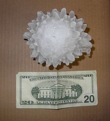
English: A large hailstone, approximately 133 mm (5 1/4 inches) in diameter, that fell in Harper, Kansas on May 14, 2004.
Français : Un grêlon de 133 mm de diamètre, tombé à Harper, dans le Kansas le 14 mai 2004. |
|||
| நாள் | ||||
| மூலம் | http://www.crh.noaa.gov/ict/scripts/viewimage.php?STORY_NUMBER=2004051418&IMG_NUM=16&loc=local | |||
| ஆசிரியர் | National Weather Service - Wichita, Kansas | |||
| அனுமதி (இக்கோப்பை மீண்டும் பயன்படுத்துதல்) |
|
| Object location | | View this and other nearby images on: OpenStreetMap |
|---|
அனுமதி
This image is in the public domain because it contains materials that originally came from the U.S. National Oceanic and Atmospheric Administration, taken or made as part of an employee's official duties.
|

|
படிமங்களுக்கான தர மதிப்பீட்டு விதிகளின் அடிப்படையில் மதிப்பிடப்பட்டு பொதுக்கோப்பகத்தில் மிகவும் தரமுயர்ந்த படிமமாக இவ்வரம்புக்குள் கணிக்கப்பட்டுள்ளது: Hailstone. நீங்கள் இதன் முன்மொழிவை இங்கு காணலாம். |
கோப்பின் வரலாறு
குறித்த நேரத்தில் இருந்த படிமத்தைப் பார்க்க அந்நேரத்தின் மீது சொடுக்கவும்.
| நாள்/நேரம் | நகம் அளவு சிறுபடம் | அளவுகள் | பயனர் | கருத்து | |
|---|---|---|---|---|---|
| தற்போதைய | 11:08, 7 செப்டெம்பர் 2009 | | 659 × 721 (60 KB) | Ks0stm | {{Information |Description={{en|1=A large hailstone, approximately 5 1/4 inches in diameter, that fell in Harper, Kansas on May 14, 2004}} |Source=http://www.crh.noaa.gov/ict/scripts/viewimage.php?STORY_NUMBER=2004051418&IMG_NUM=16&loc=local |Author=Natio |
கோப்பு பயன்பாடு
கோப்பின் முழுமையான பயன்பாடு
கீழ்கண்ட மற்ற விக்கிகள் இந்த கோப்பை பயன்படுத்துகின்றன:
- beta.wikiversity.org-திட்டத்தில் இதன் பயன்பாடு
- bg.wikipedia.org-திட்டத்தில் இதன் பயன்பாடு
- da.wikipedia.org-திட்டத்தில் இதன் பயன்பாடு
- el.wikipedia.org-திட்டத்தில் இதன் பயன்பாடு
- en.wikipedia.org-திட்டத்தில் இதன் பயன்பாடு
- en.wikiversity.org-திட்டத்தில் இதன் பயன்பாடு
- kbp.wikipedia.org-திட்டத்தில் இதன் பயன்பாடு
- lv.wikipedia.org-திட்டத்தில் இதன் பயன்பாடு
- mk.wikipedia.org-திட்டத்தில் இதன் பயன்பாடு
- pl.wiktionary.org-திட்டத்தில் இதன் பயன்பாடு
- pt.wikipedia.org-திட்டத்தில் இதன் பயன்பாடு