
படிமம்:Firthsvoe.jpg
இதைவிட அளவில் பெரிய படிமம் இல்லை.
Firthsvoe.jpg (640 × 426 படவணுக்கள், கோப்பின் அளவு: 65 KB, MIME வகை: image/jpeg)
சுருக்கம்
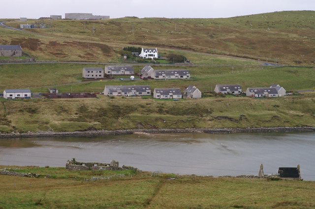
| விளக்கம் | w:Firth, Shetland, Mainland, w:Shetland. Firths Voe with housing from the oil era and pre-oil era beyond and, on the skyline, the Fraser Peterson Centre, no longer used, but built as a leisure centre for use by construction workers building w:Sullom Voe Oil Terminal. | ||
| நாள் | See image source page. | ||
| மூலம் |
This image was taken from the Geograph project collection. See this photograph's page on the Geograph website for the photographer's contact details. The copyright on this image is owned by Mike Pennington and is licensed for reuse under the Creative Commons Attribution-ShareAlike 2.0 license.
This file is licensed under the Creative Commons Attribution-Share Alike 2.0 Generic license. பண்புக்கூறுகள்: Mike Pennington
|
||
| ஆசிரியர் | See above. | ||
| அனுமதி (இக்கோப்பை மீண்டும் பயன்படுத்துதல்) |
See above. |

| Camera location | | View this and other nearby images on: OpenStreetMap |
|---|
_heading:0.00&language=ta)
| Object location | | View this and other nearby images on: OpenStreetMap |
|---|
_heading:0.00&language=ta)
அனுமதி
This file is licensed under the Creative Commons Attribution-Share Alike 2.0 Generic license.
- நீங்கள் சுதந்திரமாக:
- பகிர்ந்து கொள்ள – வேலையை நகலெடுக்க, விநியோகிக்க மற்றும் அனுப்ப
- மீண்டும் கலக்க – வேலைக்கு பழகிக்கொள்ள.
- கீழ்க்காணும் விதிகளுக்கு ஏற்ப,
- பண்புக்கூறுகள் – நீங்கள் பொருத்தமான உரிமையை வழங்க வேண்டும், உரிமத்திற்கான இணைப்பை வழங்க வேண்டும் மற்றும் மாற்றங்கள் செய்யப்பட்டிருந்தால் குறிப்பிட வேண்டும். நீங்கள் ஏற்புடைய எந்த முறையிலும் அவ்வாறு செய்யலாம், ஆனால் எந்த வகையிலும் உரிமதாரர் உங்களை அல்லது உங்கள் பயன்பாட்டிற்கு ஒப்புதல் அளிக்கும் படி பரிந்துரைக்க கூடாது.
- அதே மாதிரி பகிர் – நீங்கள் ரீமிக்ஸ் செய்தாலோ, உருமாற்றம் செய்தாலோ அல்லது பொருளை உருவாக்கினாலோ, உங்கள் பங்களிப்புகளை அல்லது இணக்கமான உரிமம் கீழ் அசலாக விநியோகிக்க வேண்டும்.
கோப்பின் வரலாறு
குறித்த நேரத்தில் இருந்த படிமத்தைப் பார்க்க அந்நேரத்தின் மீது சொடுக்கவும்.
| நாள்/நேரம் | நகம் அளவு சிறுபடம் | அளவுகள் | பயனர் | கருத்து | |
|---|---|---|---|---|---|
| தற்போதைய | 18:52, 30 சூலை 2008 | | 640 × 426 (65 KB) | MacRusgail | == Summary == {{Information| |Description=w:Firth, Shetland, Mainland], w:Shetland. Firths Voe with housing from the oil era and pre-oil era beyond and, on the skyline, the Fraser Peterson Centre, no longer used, but |
கோப்பு பயன்பாடு
பின்வரும் பக்க இணைப்புகள் இப் படிமத்துக்கு இணைக்கபட்டுள்ளது(ளன):
கோப்பின் முழுமையான பயன்பாடு
கீழ்கண்ட மற்ற விக்கிகள் இந்த கோப்பை பயன்படுத்துகின்றன:
- en.wikipedia.org-திட்டத்தில் இதன் பயன்பாடு
- eu.wikipedia.org-திட்டத்தில் இதன் பயன்பாடு
- www.wikidata.org-திட்டத்தில் இதன் பயன்பாடு