
படிமம்:Chola country.png
இதைவிட அளவில் பெரிய படிமம் இல்லை.
Chola_country.png (400 × 400 படவணுக்கள், கோப்பின் அளவு: 113 KB, MIME வகை: image/png)
சுருக்கம்
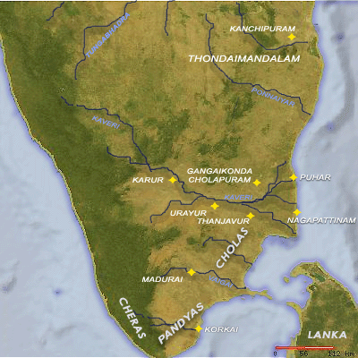
| விளக்கம் |
English: Map showing the Chola country with its major places marked. |
| நாள் | 2 ஏப்பிரல் 2006 (original upload date) |
| மூலம் | Map made using the online map generation tool found at www.planiglobe.com and modified using Adobe Photoshop. |
| ஆசிரியர் | Venu62 at ஆங்கிலம் விக்கிப்பீடியா |
அனுமதி
இந்த ஆக்கத்தின் காப்புரிமையாளரான Venu62 from en.wikipedia.org எனும் நான் இதனைப் பின்வரும் உரிமத்தின் கீழ் வெளியிடுகின்றேன்:
| இந்த கோப்பு Creative Commons Attribution-Share Alike 3.0 Unported உரிமத்தின் கீழ் உள்ளது. Subject to disclaimers. | ||
| பண்புக்கூறுகள்: Venu62 from en.wikipedia.org | ||
| ||
| This licensing tag was added to this file as part of the GFDL licensing update. |

|
GNU Free Documentation License விதிமுறைகளின் கீழ் இந்த ஆவணத்தை நகலெடுக்க, விநியோகிக்க மற்றும்/அல்லது மாற்றுவதற்கு அனுமதி வழங்கப்பட்டுள்ளது, Free Software Foundation;ஆல் வெளியிடப்பட்ட பதிப்பு 1.2 அல்லது அதற்குப் பிந்தைய பதிப்பு, மாற்றமில்லாத பிரிவுகள், முன் அட்டை உரைகள் மற்றும் பின் அட்டை உரைகள் இல்லாமல் வெளியிடப்பட்டது. GNU Free Documentation License என்ற தலைப்பில் உரிமத்தின் நகல் சேர்க்கப்பட்டுள்ளது. Subject to disclaimers. |
| This image is from Planiglobe. All maps hosted on Planiglobe are licensed under the Creative Commons Attribution 2.5 License, but Planiglobe suggests that they not be used for navigational purposes. For the purposes of this license, this clause is considered a disclaimer and not a license restriction. This file is licensed under the Creative Commons Attribution 2.5 Generic license.
|
Original upload log
Transferred from en.wikipedia to Commons by Sreejithk2000 using CommonsHelper.
The original description page was here. All following user names refer to en.wikipedia.
- 2006-04-02 02:42 Venu62 400×400× (115970 bytes) Map showing the Chola country with its major places marked. Map made using the online map generation tool found at www.planiglobe.com and modified using Adobe Photoshop.
கோப்பின் வரலாறு
குறித்த நேரத்தில் இருந்த படிமத்தைப் பார்க்க அந்நேரத்தின் மீது சொடுக்கவும்.
| நாள்/நேரம் | நகம் அளவு சிறுபடம் | அளவுகள் | பயனர் | கருத்து | |
|---|---|---|---|---|---|
| தற்போதைய | 10:32, 2 சூன் 2010 | | 400 × 400 (113 KB) | File Upload Bot (Magnus Manske) | {{BotMoveToCommons|en.wikipedia|year={{subst:CURRENTYEAR}}|month={{subst:CURRENTMONTHNAME}}|day={{subst:CURRENTDAY}}}} {{Information |Description={{en|Map showing the Chola country with its major places marked. Map made using the online map generation to |
கோப்பு பயன்பாடு
பின்வரும் 8 பக்கங்கள் இணைப்பு இப் படிமத்துக்கு இணைக்கபட்டுள்ளது(ளன):
கோப்பின் முழுமையான பயன்பாடு
கீழ்கண்ட மற்ற விக்கிகள் இந்த கோப்பை பயன்படுத்துகின்றன:
- en.wikipedia.org-திட்டத்தில் இதன் பயன்பாடு
- te.wikipedia.org-திட்டத்தில் இதன் பயன்பாடு